
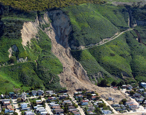
Aerial view of the La Conchita landslide after the 2005 event. (Photograph by Mark Reid, courtesy of the U.S. Geological Survey.)
Civilization exists by geological consent, subject to change without notice.
The mountain is coming down!” he shrieked. Standing directly underneath the tumbling hillside, hearing its terrible crackle and roar and watching a plume of earth spew toward the sky, the men broke and ran for their lives … He lost sight of the others as the hillside bore down. Out of the corner of one eye, he could see a house and a trailer in hot pursuit.
Ten years ago today, the tiny coastal town of La Conchita, California, experienced a terrible tragedy. The winter of 2004–2005 was unusually wet in Southern California. Many places in the steep mountains behind the urban belt had flooded and experienced landslides. Huge amounts of rain had fallen in the last weeks of December and the first weeks of January. In the sleepy coastal town of La Conchita, there was no reason to think that the winter rainy season would be unlike any other. La Conchita consisted of a few dozen houses with about 300 residents, located right on the coast on Highway 101 between the wealthier communities of Santa Barbara and Ventura. La Conchita was much more laid-back and inexpensive, with small beach cottages inhabited mostly by retired surfers, artists, beachcombers, and hippies who savored their pleasant beachfront life without Santa Barbara’s high prices and congestion.
It was also located at the base of a steep cliff made of loose sandstones and mudstones. Once deposited in ancient seas, these ancient sedimentary rocks were then uplifted by faults to heights more than 150 m (500 feet) above sea level. The cliffs were prone to landslides up and down the coast, from Malibu to the sea cliffs west of Ventura. They were formed of softer sedimentary rocks, with lots of clays that soaked up water, expanded, and became slippery when they were saturated. The bluffs above the town had many landslide scars, showing a long history of instability. In March 1995, part of the hillside had given way, covering up the houses on the street against the base of the cliff. The 1995 slide measured 120 m (400 feet) wide, 330 m (1,100 feet) long, and spread across 4 hectares (10 acres). It was greater than 30 m (100 feet) deep, with an estimated volume 1.3 million cubic meters (1.7 million cubic yards). 1995 had also been a wet year, with 390 mm (15 inches) of rain in the two weeks before the slide. No one was killed in the event, because the landslide moved relatively slowly and residents were warned to evacuate, but a number of houses were destroyed. Afterward, large retaining walls were built at the base of the slide debris to stop further movement.
Still, the residents of La Conchita were pretty mellow during the rains of 2004-2005 and did not expect anything different from previous rainy winter. Early on the morning of January 10, small mudflows started moving down the nearby canyons. Highway 101 was closed, and emergency officials and TV crews monitored the mudflows. Then at 12:30 in the afternoon, the cliff gave way, as the TV news cameras were rolling. (Video footage of this event is online and amazing to watch.) A mass of earth 350 m (1,150 feet) long and 80-100 m (260-330 feet) wide, remobilized from the unstable 1995 landslide, quickly moved downslope at 10 m/sec (33 feet/sec), faster than anyone could outrun it. Before people in the houses below could react, it had overrun almost half the town, burying and destroying 13 houses, damaging 23 others, and burying dozens of people. (For more, see the USGS report “Landslide Hazards at La Conchita, California,” by Randall W. Jibson—PDF.) Many of the houses were pushed forward as if by a mighty bulldozer and then torn apart before being buried. Emergency workers and townspeople rushed to aid people trapped under their smashed houses and rescued quite a few. Still, some houses were so deeply buried and crushed that there was no way to dig down without rescuers endangering their own lives, and there were no sounds or other signs of life. The rescuers eventually gave up, and ten people were buried in the slide mass, with memorials marking the site where they vanished. Most were eventually recovered after a lot of digging.
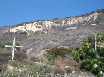
The landslide debris covering the town as of 2011, with the makeshift graves and memorials still standing from 2005. (Courtesy K. Allison Lenkeit Meezan • Foothill College, Department of Geography. This work is licensed under a Creative Commons Attribution-NonCommercial-ShareAlike 3.0 Unported License.)
After the landslide, residents rebuilt their lives and mourned their dead. Many blamed other people for the landslide, not Mother Nature and not their own decision to live in this community. Some residents filed lawsuits against the landowners on the top of the cliff, blaming the landslide on irrigation of the croplands above the cliff. Their suits were thrown out of court because geologic evidence clearly indicated that the extraordinary rains and the cliff’s unstable nature caused the landslide. Many people urged the remaining residents to sell and move elsewhere, so that the town could be bulldozed and made into a park. Because of the steep drop in housing values, no one wanted to sell at a loss. Besides, La Conchita was one of the last relatively inexpensive communities on that stretch of coast. Today, town residents are still in denial, unable or unwilling to move out. They leave memorials along the fence at the edge of the slide mass. Neither the state nor anyone else has the money or willpower to buy out residents and relocate them out of harm’s way, so they stay, waiting for the next landslide to wipe out even more of the town and claim more lives.
Just last week, the Los Angeles Times published a retrospective about the upcoming tenth anniversay of the slide. In the article, you hear the usual comments by remaining town residents: they can’t afford to move; they don’t think it will happen again; they are not worried about the risk, and so on.

Stories such as these are not new. Last year I blogged about the Oso landslide in Washington State. Just last week, landslides wiped out houses in Hoquiam, Washington. As I discussed in my book Catastrophes!, geologic hazards are everywhere, and people have to learn to live with them, and make a reasonable assessment of the risks and costs versus the benefits of living in a certain place. We Californians know about our risks of earthquakes, but disasters like tornadoes happen in the Midwest, hurricanes in the South, and the biggest killers among all natural disasters are blizzards, which the northern tier of the country experiences every year. When I taught labs about the subject in college level geology courses, I had the student rank the risk of the geological hazards (landslides, earthquakes, tsunamis, flooding) for every real estate zone in Los Angeles County. We started with the null hypothesis that people would want to live in safe places. Then we looked at real estate prices in each zone, and the result was the exact opposite: the highest land values are in the most dangerous places, especially in the coastal hillside communities like Malibu, Pacific Palisades, and the Palos Verdes Peninsula. Clearly, people are willing to live in very risky and dangerous places if they have wonderful ocean views, cool sea breezes, and never get blazing hot like the interior of Los Angeles gets in the summer time.
But this case is different. La Conchita residents learned in 1995 that the hills behind them were dangerous, and did nothing when the back streets of town vanished in the first slide. They chose to take their chances on a ticking time-bomb, and ten people lost their lives in the 2005 slide. Here we are ten years later, and nothing has changed. No matter how dangerous the setting, they won’t get out of the way. In some cases, the government steps in and works for the common good (and tries to minimize long term costs and risks to taxpayers) by condemning or buying up land too risky to live on. That has already happened at the Portuguese Bend landslide in the Palos Verdes, where no houses stand any more despite it being some of the most scenic and valuable land in California
When will the residents of La Conchita learn this lesson? How many more of them will die in the next inevitable landslide?


That’s the way some people are. Didn’t you know? They’d rather take a chance on nothing bad happening, than face reality.
John McPhee’s excellent book, “The control of nature” explains this in a very readable and non-technical style, as entertaining as a mystery novel. I’ve long thought that we would have a lot more young scientists if that book could be assigned to every junior high school student in the country.
Actually, I assign that book to EVERY intro geology class I teach, along with the textbook, and they read the chapter on the Iceland volcanoes when we cover that topic, the California landslides when we get to mass wasting, and the Atchafalaya when we cover rivers and deltas. It’s a great book for that purpose!
Even more confusing, THIS documentary says it was 1:20 p.m.
https://www.youtube.com/watch?v=Y05lc1naG7s&list=PLUfxnX0Bc2JCi9iR4McB5yBd-LzUExkCK
Please note that different sources provide diverging details about this event. Dr. Prothero’s post draws from details provided by the USGS, such as, for example, the time of the 2005 landslide, which they place at “about 12:30 p.m.” local time. Other sources differ, with the January 11, 2005 San Francisco Chronicle placing the time of the slide at “about 2 p.m.”
—Editor
Alas, the people of La Conchita are not alone in their mis-assessment of risks. Here in Northern CA, I fussed about making sure we had done the basic preparations for an earthquake or other disaster last fall, and my husband mentioned it to his co-workers. Their responses were absolutely apathetic. Why should they worry about something that might not happen?
Sigh.